Delineate a watershed. Export a map you can hand in.
Find your location on the map, click where water leaves the catchment, and Terralio
derives the watershed and its stream network from a 30 m elevation model — then
gives you a print-ready map sheet and the GIS files behind it.
Try a watershed for free
No card for the trial. A confirmed free account includes one trial delineation of up
to 1,000 km², one per account and per network: the watershed on the map. One credit pays for a
new watershed with its report, sheets and GIS files, or unlocks the trial one. Covered wherever the Copernicus 30 m DEM has data; how well a basin
delineates depends on its terrain, and every result says what the checks found
— see scope & limits.
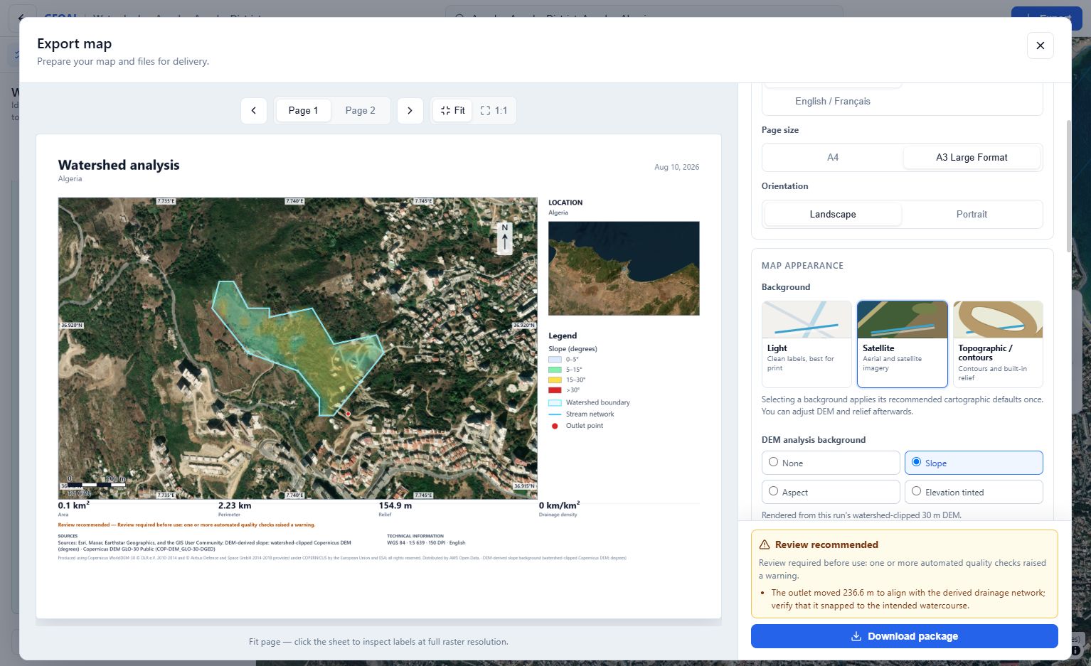
An actual Terralio Watershed export sheet — watershed near Annaba, Algeria.
What you get from one click
Every successful analysis produces the three things a watershed study actually needs.
A map sheet, laid out
A4 or A3, portrait or landscape, up to 300 DPI
Legend, scale bar and representative fraction, north arrow
Coordinate grid, locator inset, title block
Multi-page PDF with methodology and provenance, or a flat PNG
English, French, or bilingual sheets
The GIS data behind it
GeoJSON, Shapefile with projection sidecars, KML
GeoPackage and the watershed-clipped DEM as GeoTIFF
Ready-made QGIS layer styles
One ZIP with a manifest, so a colleague can reopen everything
The numbers
Area, perimeter, centroid, bounding box
Minimum, maximum and mean elevation, total relief
Mean and maximum terrain slope, elevation distribution
Longest flow path, total stream length, drainage density
Strahler stream orders and bifurcation ratio
How it works
1
Find your location
Search a place, pan and zoom the map, or type coordinates. The map is the interface.
2
Click the outlet
Click where water leaves the catchment. Terralio Watershed snaps the point onto the drainage
network it derived from the elevation data, and tells you how far it moved.
3
Delineate and export
The catchment, its streams and its metrics appear on the map. Open the export
preview, adjust the sheet, and download the map and data.
The traditional route — download a DEM, fill sinks, compute flow direction and
accumulation, extract the catchment and streams, style everything, then build a
layout with legend, scale and north arrow — is the part Terralio Watershed removes.
Data & method
Elevation
Copernicus DEM GLO-30 at 30 m resolution, read on demand from the AWS Open
Data archive. No dataset to download and no account. The dataset covers land
worldwide — that is coverage of the elevation data, not a promise that every
basin resolves at 30 m.
Flow routing
Depression filling with a Priority-Flood algorithm, then D8 flow direction and
accumulation. The stream network you click is the same one the outlet snaps to.
Quality checks
Every run is checked and labelled — snapping distance, catchment plausibility,
elevation coverage. Results that need a second look say so, on screen and on the
exported sheet.
Traceable output
Source, product version, resolution, projection, method and processing date are
written into the PDF, the GeoJSON and the ZIP manifest — so the map can be
defended in a report.
What it does well, and where it struggles
Terralio produces an automated analysis, not a certified delineation. Knowing
where it is weak is part of using it, so each result is labelled on screen and
on the exported sheet rather than presented as a verdict.
Where it is strongest
Catchments with real relief, draining to a channel the 30 m elevation model
resolves — headwaters, wadis and river reaches, up to basins of the order of a
few thousand square kilometres.
The usual hard cases
Flat and arid terrain, dense urban areas, engineered channels, dams and
reservoirs. There, the drainage a 30 m DEM can see is not always the drainage
on the ground: a run may be refused, or returned for review.
Size has a ceiling
The analysis window is widened upstream until the catchment closes, within a
bounded computation budget. A very large basin can reach that bound — the result
then states that the basin still extends past the window, instead of presenting
a partial catchment as a whole one.
Review before you rely on it
Check a result against your own knowledge of the site before using it for
engineering, safety, regulatory, insurance or emergency decisions. Terralio is
not a regulatory authority and its output is not an official delineation.
Pricing
No subscription, and credits never expire. One credit pays for one new
watershed delineation, with every export.
A free account with a confirmed email address includes 1 trial delineation of up to 1,000 km², one per account and per network: the watershed on the map.
1 credit pays for a new watershed delineation that succeeds and is saved, with its report, sheets and GIS files, or unlocks your trial watershed without recalculating it.
A delineation needs a signed-in account, and is charged only when it
succeeds. Reopening and exporting a watershed you paid for stays free, with no credits left.
What a free account gets you
A delineation runs against your account, so signing in comes first. That is also what
keeps every result you calculate, and what lets you take the work away.
A free trial, then credits
One free trial delineation, up to 1,000 km², shown on the map (one per account and per network)
One credit per new watershed that succeeds and is saved, with every export — or to unlock your trial
Reopen and re-export what you paid for as often as you like, at no further cost
A run that fails, is refused or times out costs nothing
The files, not just the picture
The print-ready PDF or PNG sheet and the GeoJSON, Shapefile and KML
GeoPackage and the watershed-clipped DEM as GeoTIFF, on a watershed you saved
Sheets without the discreet Terralio credit, on a watershed you saved
Your work, waiting for you
Every successful delineation is saved, named, and yours to reopen
Saved watersheds stay saved, and their files can be rebuilt for free
Confirming your address brings you straight back to what you were working on
Delineate your first watershed
Create your free account, click an outlet, and the catchment, its streams and its
numbers are yours — saved, and exportable as often as you need.